

Syllabus: APSC GS Paper I & II – Geography of Assam, Inter-State Relations, Federalism, Governance
Why in the News?
Recently, Assam and Meghalaya reached a temporary agreement regarding cultivation rights in the disputed Lapangap–Tapat area along the inter-state border. The agreement seeks to prevent clashes between farmers during the harvesting season and reflects the continued efforts of both states to resolve their long-standing boundary dispute through dialogue.
Background of the Dispute
- The Assam–Meghalaya border dispute originated after the creation of Meghalaya in 1972 under the North-Eastern Areas (Reorganisation) Act, 1971.
- The dispute largely stems from differing interpretations of historical boundaries.
- Meghalaya rejected the recommendations of the 1951 Bordoloi Committee, which transferred certain areas to Assam.
- Meghalaya claims that many of these areas historically belonged to Khasi, Jaintia and Garo tribal chieftains.
As a result, several stretches of the 885-km Assam–Meghalaya border became disputed.
About Meghalaya
|
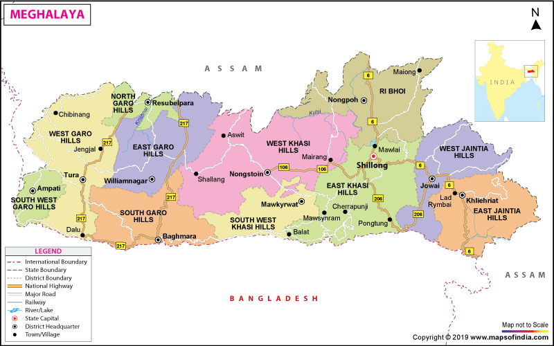
Major Areas of Difference
- After decades of claims and counterclaims, both states identified 12 disputed areas, including:
- Langpih, Block I, Block II, Deshdoomreah, Nongwah-Mawtamur, Psiar-Khanduli, Tarabari, Gizang, Hahim, Baklapara, Khanapara-Pilangkata & Ratacherra
Timeline of Resolution Efforts
- In 1983, a Joint Official Committee was constituted.
- In 1985, a commission headed by Justice Y.V. Chandrachud examined the issue.
- In 1991, both states agreed to undertake boundary demarcation with the assistance of the Survey of India.
- In 2011, disputes were narrowed down to 12 specific areas.
- In 2019, Meghalaya approached the Supreme Court seeking intervention, but the petition was dismissed.
- In 2022, Assam and Meghalaya resumed talks at the Chief Minister level and adopted a pragmatic “give-and-take” approach.
Breakthrough in 2022
- A historic agreement was signed on 29 March 2022, resolving disputes in six areas:
- Tarabari, Gizang, Hahim, Baklapara, Khanapara-Pilangkata & Ratacherra
- Under the agreement:
- Meghalaya received 18.28 sq km.
- Assam retained 18.51 sq km.
- A total disputed area of 36.79 sq km was settled.
- The negotiations were guided by five principles: Historical perspective, Ethnicity, Administrative convenience, People’s will & Contiguity of boundaries
Current Developments
- The remaining six complex areas—Langpih, Block I, Block II, Deshdoomreah, Nongwah-Mawtamur and Psiar-Khanduli—are still under negotiation.
- Recent tensions in Lapangap and Tapat highlighted the urgency of resolving these disputes.
- Clashes between Khasi and Karbi farmers over cultivation rights have periodically disturbed peace in the region.
- The latest agreement between representatives of both states allows farmers from both sides to continue cultivation in designated areas while maintaining peace and preventing conflict.
Challenges in Resolution
- Historical records are often contradictory.
- Ethnic and tribal sentiments are deeply attached to land ownership.
- Administrative control and revenue records differ between the two states.
- Frequent local clashes create trust deficits among communities.
- Border residents often face uncertainty regarding governance and public services.
Way Forward
- Both states should continue the successful model of Chief Minister-level negotiations.
- Community participation and confidence-building measures should be strengthened.
- Joint development projects in border areas can reduce tensions.
- Scientific boundary demarcation using modern geospatial technology should be expedited.
- The spirit of cooperative federalism must guide future negotiations.
Conclusion
The Assam–Meghalaya border dispute is not merely a territorial issue; it is closely linked to identity, livelihoods and regional harmony. The successful settlement of six disputed areas demonstrates that dialogue and political will can overcome long-standing differences. Resolving the remaining disputes peacefully will strengthen inter-state relations, improve the lives of border communities and serve as a model of cooperative federalism in India’s Northeast.
Key Takeaways
- Meghalaya was created under the North-Eastern Areas (Reorganisation) Act, 1971.
- Twelve areas of difference were identified between Assam and Meghalaya.
- Six disputed areas were resolved through the 2022 agreement.
- Six complex areas remain under negotiation.
- The dispute is being addressed through the principles of cooperative federalism and consensus-building.
Mains Practice Question
“The Assam–Meghalaya boundary dispute reflects the challenges of balancing historical claims, ethnic aspirations and administrative convenience in a federal polity.” Discuss the steps taken towards its resolution and the way forward. (250 words)
One-Line Wrap
The Assam–Meghalaya boundary negotiations demonstrate how dialogue, political leadership and cooperative federalism can transform long-standing territorial disputes into opportunities for regional peace and development.


Start Yours at Ajmal IAS – with Mentorship StrategyDisciplineClarityResults that Drives Success
Your dream deserves this moment — begin it here.