

WhatsApp Channel Join Now
Telegram Group Join Now
Karbi Anglong is emerging as a promising hydrocarbon exploration region within the Assam-Arakan Basin, with ongoing geological and seismic studies indicating significant petroleum and natural gas potential.
Hydrocarbon exploration in Karbi Anglong is part of India’s efforts to enhance domestic energy security by exploring frontier sedimentary basins. Although commercial production has not yet started, extensive exploration has identified several promising geological structures.
Key Highlights
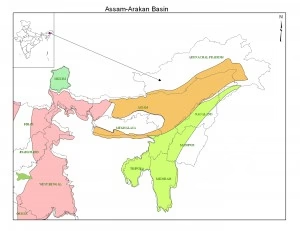
- Karbi Anglong lies within the Assam-Arakan Basin, one of India’s most productive petroleum basins, covering nearly 1.16 lakh sq. km and containing over 100 oil and gas fields.
- The exploration is spearheaded by Oil India Limited (OIL) in collaboration with Oil and Natural Gas Corporation (ONGC), Gas Authority of India Limited (GAIL) and East West Petroleum.
- The Directorate General of Hydrocarbons (DGH) awarded Exploration Block AA-ONN-2010/2 (around 400 sq. km) for detailed exploration of conventional and unconventional hydrocarbon resources.
- Seismic surveys conducted since 2006 have identified potential hydrocarbon-bearing structures in Manja, Lumbajong, Bokajan, Lumding-Dillai, and areas bordering Dima Hasao and the Naga Fold Belt.
- The region contains sedimentary formations such as the Kopili, Barail, and Tipam Formations, which are known petroleum source and reservoir rocks.
Challenges
- Dense forests, hilly terrain, and poor road connectivity increase exploration costs.
- Environmental clearances are crucial due to ecologically sensitive forests and wildlife corridors.
- Community participation and cooperation with the Karbi Anglong Autonomous Council are essential for land access and project implementation.
- Security and logistical challenges have previously delayed seismic surveys.
Assam-Arakan Basin
Tectonic History of the Basin
|
Exam Hook (Prelims)
Consider the following statements regarding hydrocarbon exploration in Karbi Anglong:
- Karbi Anglong lies within the Assam-Arakan Basin.
- The Directorate General of Hydrocarbons regulates exploration blocks under the Hydrocarbon Exploration and Licensing Policy.
- The Kopili, Barail and Tipam formations are associated with petroleum-bearing sedimentary rocks.
Which of the statements given above are correct?
(a) 1, 2 and 3
One-Line Wrap
With its favourable geology and strategic location in the Assam-Arakan Basin, Karbi Anglong is emerging as a key frontier for India’s future hydrocarbon exploration and energy security.


Start Yours at Ajmal IAS – with Mentorship StrategyDisciplineClarityResults that Drives Success
Your dream deserves this moment — begin it here.