
Syllabus: GS-III & V: Infrastructure
Why in the News?
After a 20-year wait, the Subansiri Lower Hydroelectric Project (SLHP) has started generating power, with one unit synchronised with the National Power Grid on December 1, 2025. This marks a crucial step in India’s push towards clean and stable hydropower.
A Defining Moment in India’s Hydropower Journey
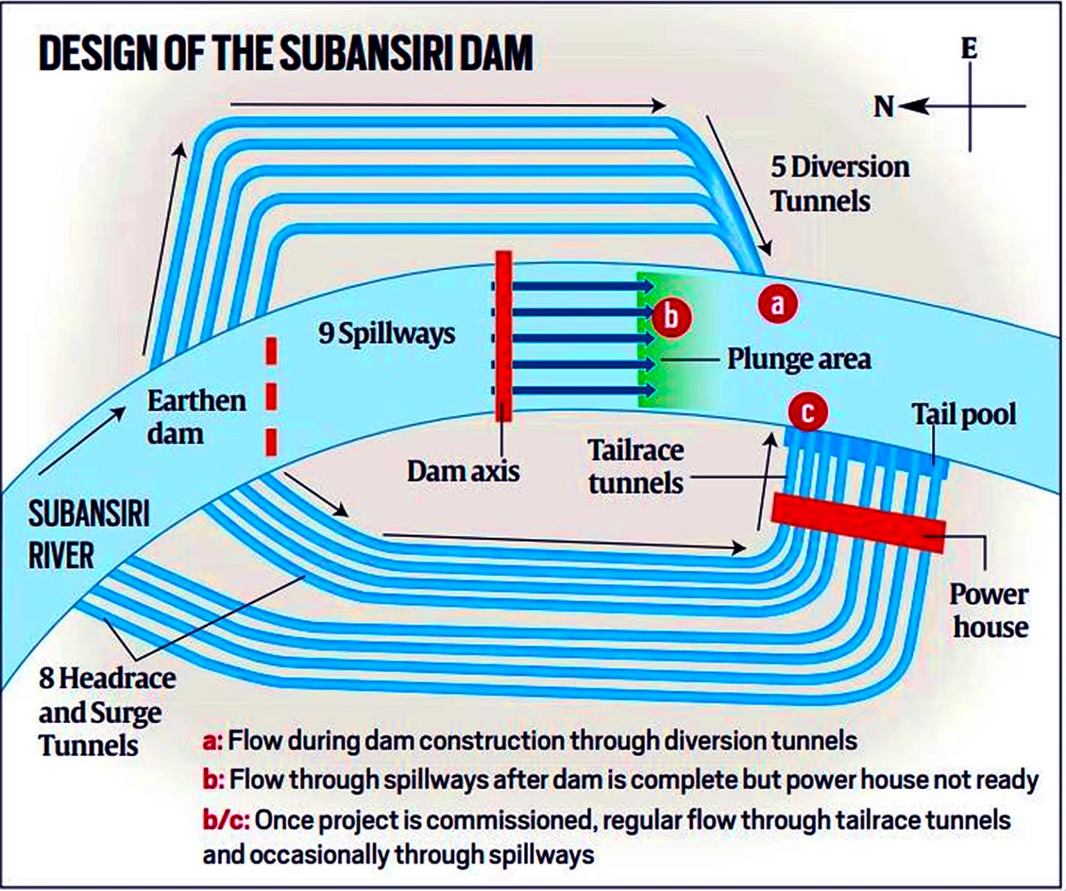
The Subansiri Lower Hydroelectric Project, located at Gerukamukh on the Assam–Arunachal Pradesh border, is India’s largest run-of-the-river hydropower project under construction. Implemented by NHPC, it will generate 2000 MW through eight units of 250 MW each.
- Unit 1 and Unit 2 have started test generation.
- Three more units are expected by December 2025.
- The full commissioning is targeted for March 2027.
Once operational, the project will supply 7.421 billion units of renewable energy per year, supporting India’s carbon-neutrality ambitions.
Understanding the Project: Key Technical Features
- Type: Run-of-the-river scheme – uses natural river flow with minimal storage.
- Developer: NHPC Ltd. (National Hydroelectric Power Corporation)
- Dam Height: 116 metres, concrete gravity dam.
- Reservoir Length: 34.5 km (storage: 1365 MCM + 442 MCM flood cushion).
- Diversion System: 5 diversion tunnels.
- Spillways: 9 spillway bays for controlled release.
- Powerhouse: Underground structure with 8 × 250 MW turbines.
These design features help balance power generation, flood moderation, and ecological flow.
About the Subansiri River
- The Subansiri River, also known as Chayul Chu in Tibet, is the largest tributary of the Brahmaputra, contributing nearly 7.92% of its total flow.
- It is a right-bank tributary of the Brahmaputra.
- It is a trans-Himalayan river flowing through Tibet (China), Arunachal Pradesh, and Assam before joining the Brahmaputra at Jamurighat in Lakhimpur district.
- Known as Gold River for its historic gold dust (Xiphoid sand).
Origin and Course
- The river originates in the mountains of Tibet, where several “Chu” streams (notably Sikung Chu) form its upper course .
- Total length: ~442 km
- ~192 km in Arunachal Pradesh
- ~190 km in Assam
- Rest in Tibet
- It enters India near Taksing at Upper Subansiri district of Arunachal Pradesh.
- It then flows along the Miri Hills, and descends into the Assam plains at Dulangmukh.
Geographical Features
- Drainage basin: ~32,640 sq km
- Known for its steep gradients, rapid flows, and braided channels in the plains.
- Important tributaries include Rangandi, Dikrong, and Kamala.

Project’s Long Journey: 20 Years of Challenges & Resilience
1. Halt in Construction (2011–2019)
Assam witnessed massive protests led by civil groups, environmentalists, and experts citing:
- Dam safety concerns,
- Seismic vulnerability,
- Downstream ecological impact,
- Risk of sudden floods.
All work stopped for eight years, leading to cost escalation from ₹6,285 crore (2002) to nearly ₹26,000 crore.
Safety Reforms and Expert Panels: How the Project Was Strengthened
To address public concerns, the Union Government constituted multiple high-level committees:
1. Technical Expert Committee (TEC), 2012
- Rejected fears of “dangerous hydrological design”.
- Recommended increased safety margins.
2. Dam Design Review Panel (DDRP), 2013
Suggested major upgrades:
- Widening dam base from 171m → 271m
- Additional cut-off walls
- Strengthened grouting and anchoring
- Enhanced seepage protection
3. National Committee for Seismic Design Parameters (NCSDP)
- Approved upgraded seismic safeguards.
4. Cumulative Impact and Carrying-Capacity Study (CWC, 2014)
Mandated:
- Minimum environmental flow of 240 cubic metres/second
- Long-term river health monitoring
- Downstream ecological protections
Ecological & Safety Measures for Downstream Assam
Key Protection Measures
- A 15-meter flood cushion to absorb sudden inflows.
- 442 MCM buffer capacity for flood moderation.
- 60 km of riverbank protection downstream.
- Raised carrying capacity (15–20%) of the Subansiri channel.
- ₹470 crore community welfare and infrastructure package for affected villages.
These steps aim to reduce flood anxiety among downstream communities.
Power Allocation: Who Gets What?
- Assam:
- Standard allocation: 208 MW
- Additional preferential: 300 MW
- 25 MW free electricity
- Arunachal Pradesh:
- 12% free power as the “host state”
Remaining power is allocated to other states, including those in the Northeast.
Importance for India’s Energy Transition
The project contributes directly to:
- India’s National Hydropower Policy goals
- Paris Agreement commitments
- 2030 renewable energy targets
- Stabilising the Northeast’s grid
- Reducing coal dependence
Exam Hook: Key Takeaways
- India’s largest run-of-river hydropower project under construction.
- 2000 MW capacity; 8×250 MW units.
- Crucial safety redesign after public protests.
- Subansiri: Trans-Himalayan river, meets Brahmaputra near Majuli.
- Reservoir: 34.5 km; dam: 116 m high.
- Environmental flow mandated: 240 cumecs.
Mains Question
“The Subansiri Lower Hydroelectric Project illustrates the complex balance between development, ecology, and public consent in the Northeast. Discuss.”



Start Yours at Ajmal IAS – with Mentorship StrategyDisciplineClarityResults that Drives Success
Your dream deserves this moment — begin it here.