Syllabus: GS – II &V: Border Dispute
Why in the News?
Assam and Mizoram have agreed to maintain the status quo along their disputed border and strengthen coordination between district officials to prevent fresh tensions and resolve local issues peacefully.
Key Highlights of the Agreement
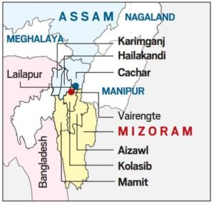
The understanding was reached during a meeting between the Deputy Commissioners of Kolasib (Mizoram) and Hailakandi (Assam) at Buhchangphai village in Mizoram.
The major decisions include:
- Both States agreed to ensure strict enforcement of the Forest (Conservation) Act, 1980, within reserved forest areas and take action against violations.
- Officials agreed to conduct joint patrolling along the inter-State border with the participation of police and forest personnel.
- Restrictions concerning oil palm and areca nut plantations, private roads and other infrastructure inside reserved forests were discussed.
- The authorities will examine objections concerning the construction of a bridge and two culverts at Ramjani Nallah, located within the Inner Line Reserve Forest.
- Both sides agreed to facilitate the movement of areca nut produced in Mizoram through Assam.
- Regular physical or virtual meetings and a dedicated WhatsApp group will help ensure quicker communication.
- The two districts will implement the Narco Coordination Centre (NCORD) protocol to strengthen cooperation against drug trafficking along the border.
About the Assam–Mizoram border dispute
The Assam–Mizoram border dispute is colonial in origin and deeply rooted in historical demarcations.
- During British rule, Lushai Hills (present-day Mizoram) was part of Assam.
- Mizoram became a Union Territory in 1972 and a full-fledged State in 1987.
- Assam’s districts of Cachar, Hailakandi and Karimganj share a 165 km boundary with Mizoram.
- The core dispute involves about 1,318 square kilometres of forested hills claimed by both States.
Colonial-era notifications at the core
Two British-era boundary definitions lie at the heart of the disagreement:
- 1875 Notification
- Issued under the Bengal Eastern Frontier Regulation, 1873.
- Drawn an Inner Line between the Cachar plains and the Lushai Hills.
- Mizoram considers this line as the only legitimate boundary, arguing that Mizo chiefs were consulted.
- 1933 Demarcation
- Boundary redrawn between Lushai Hills and Manipur.
- Assam accepts this as the constitutional boundary, based on the Survey of India map.
- Mizoram rejects it, claiming no consultation with Mizo leaders.
Recent tensions and clashes
Despite agreements to maintain the status quo, tensions have persisted.
- The 123 km disputed stretch has seen repeated confrontations.
- The most serious incident occurred on July 26, 2021, when firing between police forces led to the death of five Assam policemen.
- Incidents of alleged encroachment, destruction of plantations, and movement of security forces have fuelled mistrust.
- Issues such as illegal drug routes, forest access, and village-level land use further complicate the situation.
Why the dispute escalates
The conflict is not merely territorial; it is social, economic and political.
- Identity preservation: Both Assamese and Mizo communities fear loss of ancestral land and cultural space.
- Ethnic land rights: Strong emotional attachment to land among border residents intensifies resistance.
- Political competition: Accusations of unilateral actions by State governments raise tensions.
- Administrative ambiguity: Poorly demarcated borders increase the scope for conflict.
Efforts made so far
- Multiple official-level and ministerial-level talks held in Aizawl, Guwahati and New Delhi.
- Meetings between former Chief Ministers Zoramthanga and Himanta Biswa Sarma in the presence of the Union Home Minister.
- Agreement to continue official talks before political negotiations and to maintain strict status quo on the ground.
Why resolution is crucial
- The Northeast is central to India’s Act East Policy, connecting India to Southeast Asia.
- Ongoing disputes threaten internal security, infrastructure projects, investment, and regional integration.
- Prolonged conflicts risk turning administrative disputes into long-term security challenges.
Way forward: A realistic solution
A durable settlement requires cooperation, not confrontation.
- Strengthening the Inter-State Council (Article 263) to institutionalise dialogue.
- Using the North Eastern Zonal Council for region-wide consensus-building.
- Scientific boundary demarcation using satellite imagery, Geographic Information Systems and drone surveys.
- Confidence-building measures, including joint patrolling and local-level coordination.
- Community engagement to prevent misinformation and reduce ground-level tensions.
- Development-focused interventions in border areas to reduce economic insecurities.
Conclusion
The Assam–Mizoram boundary dispute is a reminder that colonial legacies still shape present-day governance. While history explains the conflict, the future depends on dialogue, trust, and cooperative federalism. A peaceful resolution will not only secure borders but also unlock the developmental potential of the Northeast, strengthening India’s unity and strategic depth.
Exam Hook –
“The Assam–Mizoram border dispute is rooted in colonial-era demarcations and competing claims over land and identity. Discuss the causes and suggest a way forward.”



Start Yours at Ajmal IAS – with Mentorship StrategyDisciplineClarityResults that Drives Success
Your dream deserves this moment — begin it here.