Syllabus: GS Paper III & V: Border Management
Why in the News?
Meghalaya Cabinet Minister has urged to expedite the second phase of border talks with Assam to bring clarity and peace among residents living along the inter-state border. The two states are currently engaged in resolving six remaining disputed sectors after successfully settling six of the twelve long-standing conflict zones in March 2022.
The second phase of talks, covering areas such as Langpih, Borduar, Deshdoomreah, Block I–II, Psiar-Khanduli, and Nongwah-Mawtamur, aims to end the remaining territorial disputes that have occasionally led to tensions, violence, and insecurity for border residents.
About Meghalaya and the Assam–Meghalaya Border
- Total area of Meghalaya: 22,720 sq. km
- Total districts: 12 (with demands to upgrade Sohra and Dadenggre into new districts)
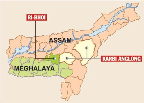
- Boundary shared with Assam: 884 km
- Neighbouring Assam districts: Cachar, Dima Hasao, West Karbi Anglong, Morigaon, Kamrup Metropolitan, Kamrup, Goalpara, and South Salmara-Mankachar.
Meghalaya was carved out of Assam in 1972, leading to boundary ambiguities inherited from colonial and early post-independence administrative arrangements.

Origin of the Dispute
- Background:
- The conflict originated after Meghalaya’s formation in 1972 under the North Eastern Areas (Reorganisation) Act, 1971.
- The reorganisation was based on the 1951 Gopinath Bordoloi Committee’s recommendations, which sought to demarcate tribal areas.
- Core of the Dispute:
- Meghalaya rejected the Bordoloi Committee’s demarcation, claiming that parts of present-day East Jaintia Hills, Ri-Bhoi, and West Khasi Hills belonged historically to tribal chieftains under the Khasi-Jaintia Hills Autonomous District Council (KHADC).
- Assam contested these claims, citing administrative control and lack of documentary evidence from Meghalaya.
- Most Contested Region:
- Langpih (West Khasi Hills) — historically part of Kamrup but claimed by Meghalaya as a Khasi area.
- It remains a symbol of the unresolved inter-state friction and has witnessed multiple incidents of tension and police stand-offs.
Historical Timeline of Dispute Resolution Efforts
| Year | Key Development |
| 1983 | Joint committee formed by Assam and Meghalaya to resolve the dispute. |
| 1985 | A high-level panel headed by Justice Y.V. Chandrachud was constituted by the Centre to examine the boundary claims. |
| 1991 | Both states agreed to undertake demarcation with Survey of India’s assistance. |
| 2001 | Meghalaya Assembly passed a resolution seeking Central intervention, opposed by the Assam Assembly. |
| 2011 | The dispute narrowed to 12 areas of difference after decades of negotiations. |
| 2019 | Meghalaya approached the Supreme Court to direct Central mediation, but the petition was dismissed. |
| 2022 | Chief Ministers Conrad K. Sangma (Meghalaya) and Himanta Biswa Sarma (Assam) adopted a “give-and-take” approach, signing an MoU resolving 6 of 12 disputed areas. |
| 2023–25 | Regional committees established to handle Phase-II talks on remaining areas. Boundary pillars installation began in the Hahim area. |
Principles Adopted for Resolution
Both states agreed to use five key principles for determining ownership and administrative control of disputed areas:
- Historical Perspective – examining historical records and administrative maps.
- Ethnicity – considering the ethnic and tribal composition of the population.
- Continuity with Boundaries – maintaining practical administrative continuity.
- People’s Will – factoring in the preference of local residents.
- Administrative Convenience – ensuring effective governance and service delivery.
Current Status (2025)
Resolved Areas (Phase I – 2022):
- Tarabari
- Gizang
- Hahim
- Baklapara
- Khanapara–Pillangkata
- Ratacherra
- Total area resolved: 36.79 sq. km
- 18.51 sq. km in Assam
- 18.28 sq. km in Meghalaya
Pending Disputes (Phase II – Ongoing):
- Langpih
- Borduar
- Deshdoomreah
- Block I–II
- Psiar–Khanduli
- Nongwah–Mawtamur
Both governments have agreed to conduct joint verification, install boundary pillars, and pursue socioeconomic cooperation projects in the border zones.
Significance of Resolution
- Internal Security and Peacebuilding: Prevents border clashes, ethnic tensions, and militant influence.
- Strengthens law and order in sensitive tribal regions.
- Cooperative Federalism: Exemplifies Centre-facilitated, state-led resolution — a model for other inter-state disputes (e.g., Assam–Arunachal, Assam–Mizoram).
- Economic and Infrastructure Integration: Enhanced peace enables cross-border trade, transport, and development projects like the proposed joint irrigation and hydropower project.
- Social Stability and Livelihood Security: Ensures land rights, education, and health access for border residents who often fall in governance vacuums.
Challenges Ahead
- Residual Tensions in Langpih: Historical grievances and competing tribal claims remain deeply rooted.
- Encroachments and Illegal Settlements: Unclear demarcations have led to overlapping administrative control.
- Community Mistrust: Some groups perceive the give-and-take formula as a loss of ancestral land.
- Political Sensitivity: Frequent electoral rhetoric risks politicising the settlement process.
- Implementation Gaps: Boundary pillar installation and local consultations are progressing slowly.
Way Forward
- Institutionalise the Peace Process: Establish a Permanent Inter-State Boundary Commission with technical and social representation.
- People-Centric Approach: Conduct Gram Sabha consultations in disputed zones.
- Implement confidence-building measures such as cooperative markets and joint development councils.
- Use of Technology: Deploy GIS mapping and drone surveys to demarcate borders precisely.
- Involve NESAC (North Eastern Space Applications Centre) for scientific validation.
- Central Mediation Support: Continue Home Ministry’s facilitation and ensure equal political will from both states.
- Development as a Peace Dividend: Accelerate joint projects — roads, irrigation, education — to transform conflict-prone zones into development corridors.
Conclusion
The Assam–Meghalaya border dispute reflects the complex legacy of post-colonial administrative divisions in India’s Northeast.
The successful resolution of six sectors and ongoing dialogue underlines a shift from confrontation to cooperation — a hallmark of India’s federal maturity.
Sustained political commitment, community participation, and scientific boundary demarcation can make the Assam–Meghalaya border a frontier of peace, not friction, paving the way for a stable and secure Northeast.
Mains Practice Question
Q. Discuss the origin and evolution of the Assam–Meghalaya border dispute. How can cooperative federalism and people-centric governance ensure lasting peace and security in inter-state border regions? (250 words)


Start Yours at Ajmal IAS – with Mentorship StrategyDisciplineClarityResults that Drives Success
Your dream deserves this moment — begin it here.