

UPSC 2025 — Short Answer Set
(Q4, Q5, Q6, Q7, Q14, Q15, Q16, Q17)
Q.4 How are climate change and the sea level rise affecting the very existence of island nations? Discuss with examples. (Answer in 150 words)
Intro (1–2 lines)
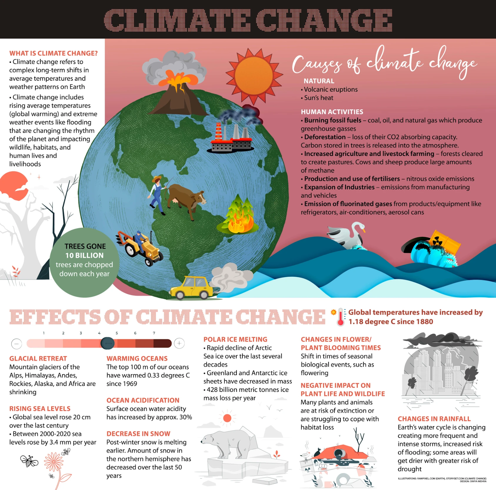
Small Island Developing States (SIDS) face an existential threat as rising seas, ocean warming/acidification, and intensifying extremes erode land, livelihoods, and even legal claims to statehood.
Impacts with examples
- Chronic inundation & shoreline erosion: Repeated tidal flooding shrinks habitable land and damages homes, roads, and ports.
- Saltwater intrusion: Freshwater lenses on low-lying atolls turn brackish, undermining drinking water, agriculture, and public health.
- Stronger storm surges: Higher baselines + cyclones amplify disaster losses and displacement.
- Coral bleaching & reef loss: Warmer, acidic seas degrade natural breakwaters, cutting fisheries and tourism revenue.
- Heat and disease burdens: Rising temperatures expand vector-borne disease windows and raise heat-stress risks.
Country snapshots
- Maldives: Mean elevation ~1–2 m; investing in artificial/elevated islands (e.g., Hulhumalé) while outer atolls lose land and potable water.
- Kiribati & Tuvalu: Frequent king-tide flooding; policies for “migration with dignity.”
- Fiji & Marshall Islands: Village relocations, elevated roads/schools, climate-resilient building codes.
- Vanuatu: Recurrent severe cyclones magnify infrastructure and livelihood losses.
- Socio-cultural loss: Submergence threatens sacred sites, burial grounds, languages, and place-based identities.
Existential stakes & way forward
Existential stakes
- Uninhabitability: Flooding + brackish water jeopardize housing, health, and food security.
- Cultural loss: Displacement severs ties to landscapes, rituals, identity.
- Legal/personhood risks: Receding coasts raise questions on statehood continuity and EEZ/baselines.
- Debt & insurance traps: Rebuilding deepens debt; premiums rise or coverage withdraws.
- Security & governance: Dispersed resettlement strains services, voting, representation.
Way forward
- Rapid mitigation: Align NDCs with 1.5°C; cut short-lived climate pollutants.
- Predictable finance: Scale adaptation + loss-and-damage funds; debt-for-climate swaps, regional risk pools.
- Nature-based buffers: Restore mangroves, seagrass, reefs to dissipate waves and support fisheries.
- Engineered protection: Context-specific seawalls, raised platforms, land reclamation where viable.
- Water security: Rainwater harvesting, desalination, aquifer protection.
- Planned relocation: Community-led, rights-based moves; regional compacts—migration with dignity.
- Early warning & resilient services: Cyclone-proof health/education; redundant power/communications.
- Legal safeguards: Fix maritime baselines, recognize deterritorialized statehood, protect diaspora voting.
Conclusion (2–3 lines)
Without fast mitigation and justice-oriented finance, several SIDS risk functional uninhabitability within decades. A combined strategy—reef/mangrove restoration, resilient infrastructure, secure water, legal protections, and dignified mobility—can keep communities safe while preserving sovereignty and identity.
Q.5 What are non-farm primary activities? How are these activities related to physiographic features in India? Discuss with suitable examples. (Answer in 150 words)
Intro / Definition
Non-farm primary activities are extractive/use-of-nature occupations other than field-crop cultivation—notably pastoralism/livestock rearing, fishing (marine & inland), forestry/NTFP collection, and mining & quarrying, plus site-adjacent primary processing (e.g., sawmills, salt pans).
Physiographic controls & examples
Coasts & continental shelf: Shelf width, currents, and upwelling shape marine fisheries.
- West coast (narrow shelf, upwelling): rich pelagic fisheries (sardine, mackerel) in Kerala–Karnataka–Goa.
- East coast (wider shelf, river deltas): estuarine/brackish aquaculture (shrimp) in Andhra–Odisha, Sundarbans.
River systems & floodplains: Inland fisheries thrive in Ganga–Brahmaputra floodplains and in reservoirs (Hirakud, Tungabhadra, Nagarjuna Sagar).
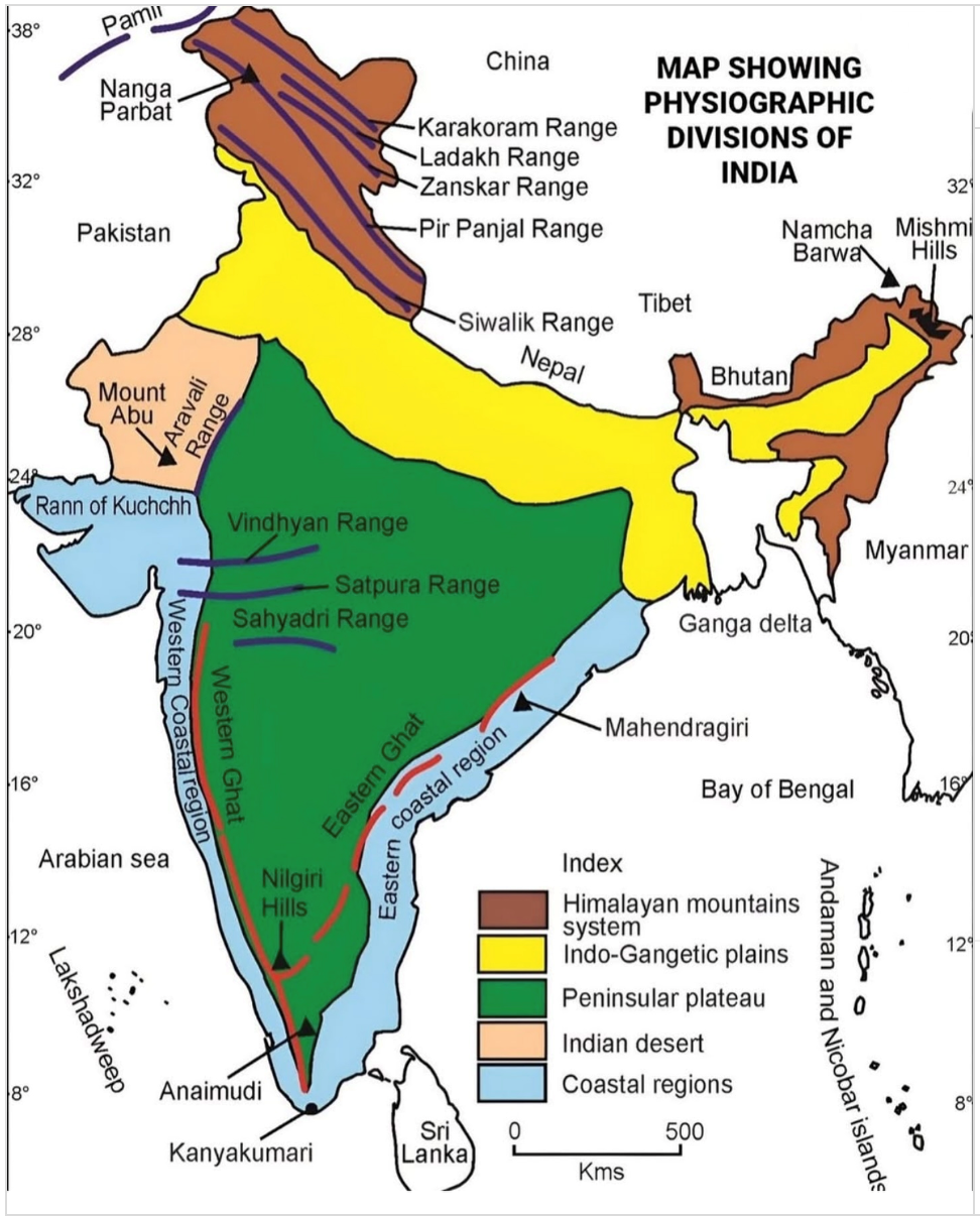
Plateaus & ancient shields: The Peninsular Plateau (gneiss, schists) hosts iron ore (Odisha–Chhattisgarh–Jharkhand), bauxite (Odisha), manganese (Nagpur–Bhandara), gold (Kolar region); Aravalli yields lead–zinc, marble; Rajasthan has gypsum, phosphate.
Mountains & forests: Himalayan conifers (timber) and NE India bamboo underpin forestry/NTFP (lac, honey, medicinal plants); Western Ghats support spices & NTFP.
Arid/semi-arid tracts: Pastoralism (camel, sheep) in Thar; transhumance (Gaddis, Bhotiyas) in Himalayas; salt pans in Rann of Kutch, Marakkanam (TN).
Climate & soils: Monsoon regime, salinity, alluvium laterites, and slope dictate species availability, fodder cycles, and mineability.
Why it matters today (hidden demand)
- Livelihood diversification & resilience for rural households.
- Export earnings (seafood, minerals); energy security (coal, lignite—while balancing environment).
- Sustainability imperatives: regulated mining, community forestry (JFM), blue economy, and value-addition (cold chains, fish processing) to enhance incomes without degrading ecosystems.
Conclusion
India’s physiographic mosaic scripts where and how non-farm primary activities cluster; policy must align resource use with ecological limits and local rights.
Q.6 Explain briefly the ecological and economic benefits of solar energy generation in India with suitable examples. (Answer in 150 words)
Intro
Falling tariffs and supportive policy have turned solar into India’s anchor of clean, secure, and affordable power, with benefits that span environment, economy, and inclusion.
Ecological benefits
- Low lifecycle emissions & air-quality gains: Displaces coal generation, cutting CO₂, SO₂, NOx, PM—major public-health benefits in power-dense states.
- Water savings: PV uses far less water than coal for generation; floating/canal-top solar additionally reduces evaporation (reservoirs, canals).
- Land-smart options: Rooftop, agrivoltaics, and wasteland siting minimize biodiversity conflicts; mine-void/ash-pond repurposing converts degraded land to clean power.
- Grid-friendly peaking: Solar output coincides with daytime cooling loads, reducing diesel backup use and urban heat-island stress when rooftop is scaled.
Economic benefits
- Energy security & import bill relief: Less exposure to volatile coal/LNG imports; improves current account.
- Low, predictable costs: Ultra-mega parks deliver globally competitive tariffs, de-risking industry; distributed solar cuts T&D losses.
- Jobs & local value chains: Employment in EPC, O&M, modules, inverters, mounting structures; MSME opportunities in rooftops and micro-grids.
- Inclusive growth: PM-KUSUM-type farm-solar enables irrigation access and sell-back income; rural schools/PHCs gain reliable power.
Examples
Bhadla (Rajasthan), Pavagada (Karnataka), Kurnool/Rewa (AP/MP)—utility-scale parks driving down tariffs; Rewa supplies Delhi Metro.
Canal-top (Gujarat) and floating solar (e.g., on thermal plant reservoirs) showcase water–energy synergies.
Rooftop programs in Gujarat/Maharashtra/Delhi expand urban clean power.
Conclusion / Way forward
Maximise co-benefits with storage & grid-flexibility, domestic manufacturing + recycling (EPR), agrivoltaics on dryland, and rooftop for demand-side relief—so solar delivers clean air, resilient water, and competitive industry together.
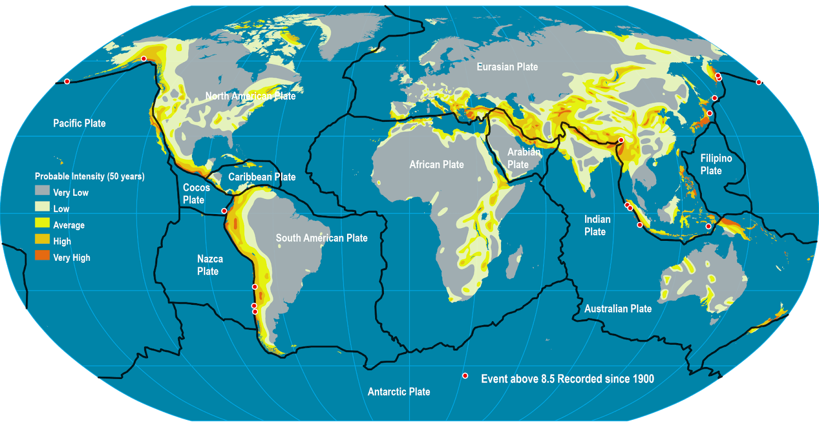
Q.7 What are Tsunamis? How and where are they formed? What are their consequences? Explain with examples. (Answer in 150 words)
Intro
Tsunamis are long-wavelength sea waves generated by the sudden vertical displacement of a large water column. In deep ocean they move fast with small amplitudes; near coasts, shoaling compresses energy, producing rapid drawdown and destructive run-up.

How & where (genesis and hotspots)
- Megathrust earthquakes at subduction zones (Mw ≥ 7.5) are the main cause.
- Also: submarine/coastal landslides, volcanic explosions or caldera/flank collapse, and rarely meteoritic impacts.
- Hotspots: Pacific Ring of Fire, Sunda–Andaman trench (Indian Ocean), Hellenic Arc (Mediterranean), Caribbean.
- Indian context: Andaman–Sumatra and Makran subduction zones are key sources.
Wave dynamics (why so destructive)
Deep-ocean speed v ≈ √(g·h) can exceed 600–700 km/h; wavelengths reach hundreds of km.
Onshore approach: height rises, speed drops, currents intensify; multiple waves may arrive minutes–hours apart (later waves can be larger).
Consequences
- Inundation and scouring cause structural failures of buildings, bridges, ports.
- Saltwater contamination of soils/aquifers; spikes in water-borne disease.
- Ecosystem damage to reefs, mangroves, wetlands; long-term livelihood losses (fisheries, tourism).
- Cascading industrial hazards (chemical/nuclear); psychosocial trauma and displacement.
Examples
- 2004 Indian Ocean (Sumatra–Andaman): catastrophic losses in Tamil Nadu, Andaman–Nicobar, Sri Lanka, Thailand.
- 2011 Tōhoku, Japan: extreme run-up; Fukushima nuclear accidents.
- 1883 Krakatau, 2018 Anak Krakatau (volcanic collapse), 1998 PNG (landslide-tsunami).
- 1945 Makran affected Oman–Pakistan, recorded along Gujarat/Maharashtra coasts.
Risk reduction / India’s approach
- Early warning & last-mile alerts: Indian Tsunami Early Warning Centre (INCOIS, Hyderabad) within the Indian Ocean Tsunami Warning & Mitigation System; sirens, cell-broadcast, community drills.
- Land-use & design: hazard zoning, set-back lines, vertical evacuation structures, resilient siting of critical facilities.
- Natural buffers: conserve/restore mangroves, dunes, reefs; keep evacuation routes/signed.
Conclusion
Tsunami risk cannot be eliminated, but science-led early warning, resilient planning, and healthy coastal ecosystems can sharply cut fatalities and losses—turning coastal vulnerability into preparedness and survivability.
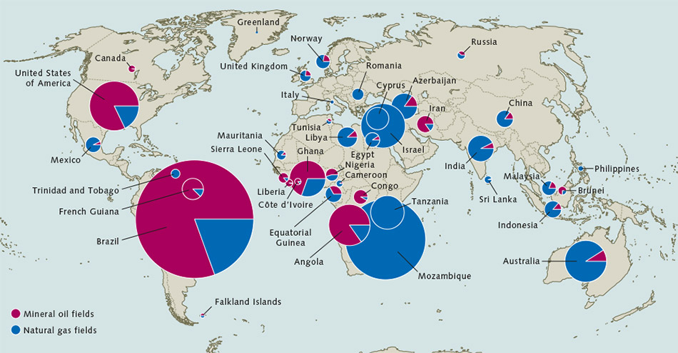
Q.14 Give a geographical explanation of the distribution of offshore oil reserves of the world. How are they different from the onshore occurrences of oil reserves? (Answer in 250 words)
Intro
Offshore reserves cluster where plate-tectonic architecture + thick marine/deltaic sediments + effective seals created prolific petroleum systems. Technology/price cycles decide what is commercially “real”.
Geographical Distribution : Logic and Examples
- Passive rifted margins (salt/turbidites): Gulf of Mexico (salt diapirs), Brazil pre-salt (Santos/Campos)—lacustrine source, carbonate reservoirs under salt; West Africa transform margin (Niger Delta–Angola deepwater) with turbidite fans.
- Temperate shelves/rifts: North Sea (UK/Norway)—Jurassic source rocks, chalk/sandstone reservoirs; mature infrastructure enables late-life tie-backs.
- Epicontinental/platform seas: Persian/Arabian Gulf—giant carbonate platforms (e.g., Upper Zakum).
- Deltaic/forearc SE Asia: Malaysia–Indonesia–Brunei (Mahakam, Sarawak); South China Sea margins.
- Indian context: Bombay High (carbonate build-ups), KG deepwater (channel–levee/turbidites), Cauvery/Mahanadi offshore; Makran frontier risk.
- Frontiers: Arctic shelves (Barents/Kara/Beaufort)—resource-rich but constrained by ice, ecology, and economics.
How offshore differs from onshore (beyond location)
- Geology/traps: Offshore commonly younger Cenozoic clastics/carbonates, salt-related traps and deepwater turbidites; onshore includes many older super-giants (Mesozoic Middle East) with accessible anticlines.
- Technology & costs: Seismic under salt, dynamic positioning rigs, deepwater subsea systems, FPSOs, long lead times, higher breakevens; onshore = cheaper pads/pipelines, easier workovers.
- Risk & regulation: Met-ocean hazards (hurricanes/ice), geohazards (shallow gas, slope failures, gas hydrates); spill complexity (Deepwater Horizon, 2010). Offshore governed by UNCLOS/EEZ, multi-agency HSE; onshore emphasises land acquisition, community impact, air/water rules.
- Infrastructure & impacts: Marine logistics, decommissioning liabilities, fisheries/blue-economy conflicts; onshore has resettlement and surface-footprint issues.
- Carbon & transition: Offshore can adopt platform electrification (from shore wind), CCS in depleted fields, methane abatement; onshore often higher flaring/leak risks in legacy assets.
Conclusion (hidden demand)
Offshore oil is a tectonics-plus-technology story concentrated on continental margins and delta systems. It remains material to supply but demands top-tier safety, ecological safeguards, and low-carbon operations, while countries—India included—use it as a bridge toward a diversified, cleaner energy mix.
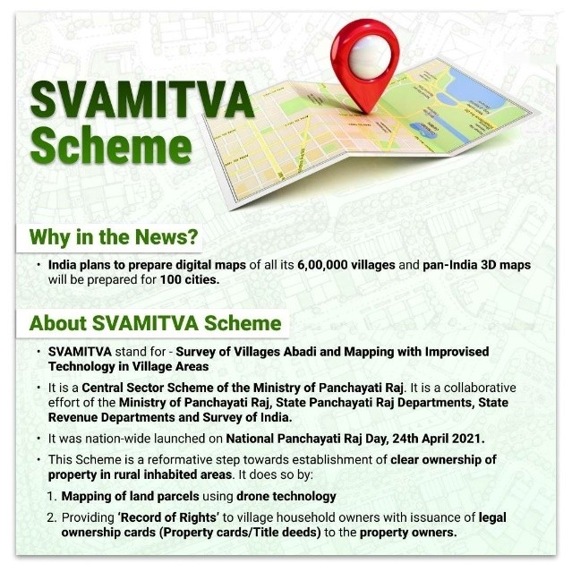
Q.15 How can Artificial Intelligence (AI) and drones be effectively used along with GIS and RS techniques in locational and areal planning? (Answer in 250 words)
Intro
AI and drones amplify GIS (analysis) and RS (observation) by adding cm-level data, rapid updates, and predictive insight—crucial for site selection (locational) and zoning/layout (areal) planning.

Integrated workflow (how it works)
Observe: RS (CartoSat/Sentinel/Landsat) for multi-season imagery; drones (RGB/LiDAR/thermal) for orthomosaics, DSM/DTM, tree canopies, roof conditions.
Classify & detect (AI): CNN/U-Net models for land-use/land-cover, slum/encroachment detection, pothole/roof damage, illegal sand mining, and waterbody change.
Analyse (GIS + MCDA): Multi-criteria suitability (slope, soil, flood, access, ecology) with AI-learned weights from past project outcomes; route optimisation for buses/ambulances/solid waste.
Simulate (digital twins): AI-driven flood/heat/traffic scenarios; test zoning and green-blue networks before execution.
Ground-truth & monitor: Drones collect training labels, as-built verification, and post-disaster rapid mapping; dashboards close the loop for iterative plans.
India-specific use cases
- SVAMITVA: drone cadastral mapping → property cards, fair taxation, service delivery in villages.
- PM Gati Shakti: GIS freight corridors; AI to forecast OD flows and site multimodal logistics parks.
- Urban heat & flood micro-plans: Ahmedabad/Surat ward-level cooling maps; Brahmaputra floodplain encroachment checks.
- Coasts & CRZ: RS + drones to delineate no-build buffers, mangrove health, and beach nourishment needs.
Governance & caveats (hidden demand)
- Regulation & ethics: DGCA flight permissions, NPNT, no-fly zones; privacy-by-design, consent for household-scale imagery.
- Bias & inclusion: Audit models to avoid algorithmic bias against informal areas; multilingual grievance portals.
- Capacity & standards: Train ULBs; adopt OGC standards, open-source stacks (QGIS/PostGIS), and public data commons.
Conclusion
When embedded in lawful, ethical, and participatory practice, AI + drones with GIS/RS turn plans into evidence-led, risk-aware, and pro-poor city/region designs.
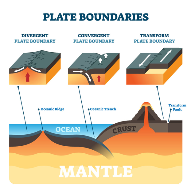
Q.16 Discuss how the changes in shape and sizes of continents and ocean basins of the planet take place due to tectonic movements of the crustal masses. (Answer in 250 words)
Intro
Because the lithosphere is segmented into mobile plates, Earth’s continents and ocean basins undergo continual reconfiguration; creation at ridges is balanced by destruction at trenches.
Key mechanisms
- Rifting → new oceans: Upwelling stretches continents; triple junctions and rifts evolve to seafloor spreading (e.g., East African Rift → Red Sea/Adén type future ocean).
- Seafloor spreading: New oceanic crust at mid-ocean ridges widens basins (e.g., Atlantic since Pangaea breakup).
- Subduction & arc systems: Old ocean floor is consumed at trenches; arcs/back-arc basins reshape margins (e.g., Pacific shrinking, Sea of Japan opening).
- Collision & orogeny: Continents collide, shorten and thicken (e.g., India–Eurasia → Himalaya–Tibet), changing continental outlines and river pathways.
- Terrane accretion & strike-slip translation: Exotic blocks weld onto continents (Alaska/Canada’s Cordillera); transform faults (San Andreas) laterally shift coastlines.
- Salt/delta tectonics & sediment loading: Margin delta systems (Amazon, Niger, Ganga-Brahmaputra) prograde coastlines, altering basin shape; isostasy and dynamic topography (mantle flow/plumes) uplift or depress regions without plate edges.
Ocean vs continent evolution (sizes)
- Oceans: Area changes with ridge length/spreading rates vs subduction consumption: Atlantic grows, Pacific contracts. Oceanic lithosphere is young (<200 Ma).
- Continents: Grow by accretion and magmatism; lose edges by rifting. Shapes evolve via mountain building, basin inversion, and coastline migration from uplift/sediment supply.
Evidence (hidden demand)
- Magnetic stripes/age bands on ocean floor; GPS plate velocities; paleomagnetism, seismic tomography, orogenic belts and sutures (e.g., Indus–Tsangpo).
India link
- Himalaya uplift re-routed sediments to build the Bengal Fan (world’s largest), modifying the Indian Ocean margin; Andaman arc and Laccadive–Chagos ridge reflect past plate reorganisations.
Conclusion
Through the Wilson cycle of rift–drift–subduction–collision, continents and oceans continually redraw their boundaries—a slow but relentless tectonic choreography.
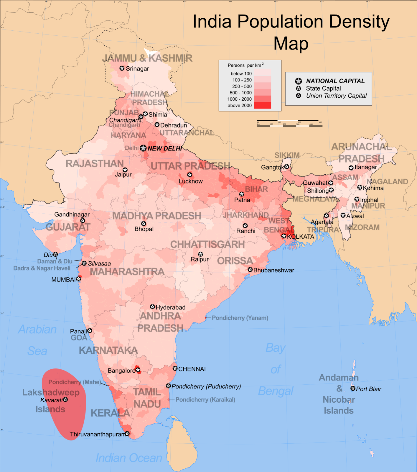
Q.17 Discuss the distribution and density of population in the Ganga River Basin with special reference to land, soil and water resources. (Answer in 250 words)
Intro
India’s largest and most populous basin shows a north–south and west–east contrast: sparse Himalayan headwaters to very dense alluvial plains and delta. The pattern mirrors land capability, soil fertility, and water availability/risks.
Spatial pattern & resource linkages
- Upper Himalaya (Uttarakhand): Steep slopes, thin soils, landslide risk, short growing season → scattered villages, low densities, out-migration. Water abundant in streams but arable land scarce.
- Terai–Bhabar belt: Recent alluvial (khadar) soils, high groundwater tables, level land → higher rural densities; expansion of rice–wheat and dairying.
- Ganga–Yamuna Doab (W. UP): Deep, loamy alluvium + Upper Ganga Canal network and tubewells → among densest rural belts; sugarcane–wheat systems, peri-urban growth along GT Road/rail; waterlogging/salinity in canal commands.
- Middle Ganga Plain (E. UP–Bihar): Very fertile new alluvium, but flood-prone (Ghaghara, Gandak, Kosi) → dense settlement on levees/older terraces; fragmented holdings, seasonal migration. Arsenic in shallow aquifers (parts of Bihar/UP) constrains safe water.
- Lower Ganga–Hooghly Plain & Delta (W. Bengal): High densities with rice–fish–jute; navigable water + port access anchor Kolkata–Howrah–Haldia urban-industrial belt; coastal blocks face salinity ingress and subsidence.
- Urban nodes/corridors: Lucknow–Kanpur–Prayagraj–Varanasi–Patna–Kolkata along alluvial terraces where land is stable, serviced, and water is treatable.
Why density is high overall
Flat cultivable land, nutrient-rich alluvium (khadar/bhangar), multi-crop potential, and dense canal–groundwater grids supported agrarian surplus and industry; religious–cultural magnets (Varanasi, Prayagraj) add pull.
Challenges of high density (hidden demand)
- Hydro-hazards: Recurrent floods/embankment breaches, riverbank erosion; encroachment of floodplains raises exposure.
- Water stress/quality: Groundwater overdraft, falling water tables; arsenic/fluoride/nitrate contamination; rural handpump dependence.
- Soil degradation: Waterlogging/salinity in canal commands; declining organic carbon from intensive rice–wheat cycles.
- Public health & sanitation: Sewage overflow, low FSSM coverage, disease outbreaks after floods.
- Urban pressures: Peri-urban sprawl on prime farmland; solid-waste mismanagement; heat-island intensification.
- Livelihood fragility: Land fragmentation, disguised unemployment, high climate sensitivity of smallholders.
- Ecosystem loss: Wetland/marsh shrinkage, mangrove loss in delta; biodiversity decline.
- Governance complexity: Multi-state basin coordination gaps; weak enforcement of zoning/CRZ/floodplain norms.
Way forward (risk-aware density management)
- Flood resilience: Floodplain zoning, no-build buffers, raised plinths/vertical evacuation, real-time warnings; room-for-river where feasible.
- Water security: Conjunctive use (canal + groundwater), managed aquifer recharge, arsenic-safe piped networks, metering & leak control.
- Soil & farming systems: Drainage rehab, salt-tolerant/short-duration crops, crop diversification (pulses/oilseeds), residue management/composting.
- Sanitation & waste: Universal sewer+FSSM, decentralised STPs with treated-water reuse for parks/industry; solid-waste segregation and biomethanation.
- Urban form: Transit-oriented development on safe terraces (not floodplains), protection of urban/ peri-urban wetlands and blue-green corridors.
- Livelihoods: Rural non-farm clusters (food processing, textiles, services), skill programs, climate-risk insurance.
- Institutions: Basin-level authority for data-sharing & operations (dams, barrages); community-based water stewardship; strict embankment maintenance.
Conclusion
The Ganga basin concentrates people where good land, fertile soils, and reliable water coincide. Sustaining livability now depends on risk-aware land–water governance that pairs flood and water-quality management with resilient agriculture, sanitation, and smarter urban growth.
Share This Story, Choose Your Platform!
Start Yours at Ajmal IAS – with Mentorship StrategyDisciplineClarityResults that Drives Success
Your dream deserves this moment — begin it here.