

Syllabus: GS-III & V: Infrastructure
Why in the News?
After a 20-year wait, the Subansiri Lower Hydroelectric Project (SLHP) has started generating power, with one unit synchronised with the National Power Grid on December 1, 2025. This marks a crucial step in India’s push towards clean and stable hydropower.
A Defining Moment in India’s Hydropower Journey
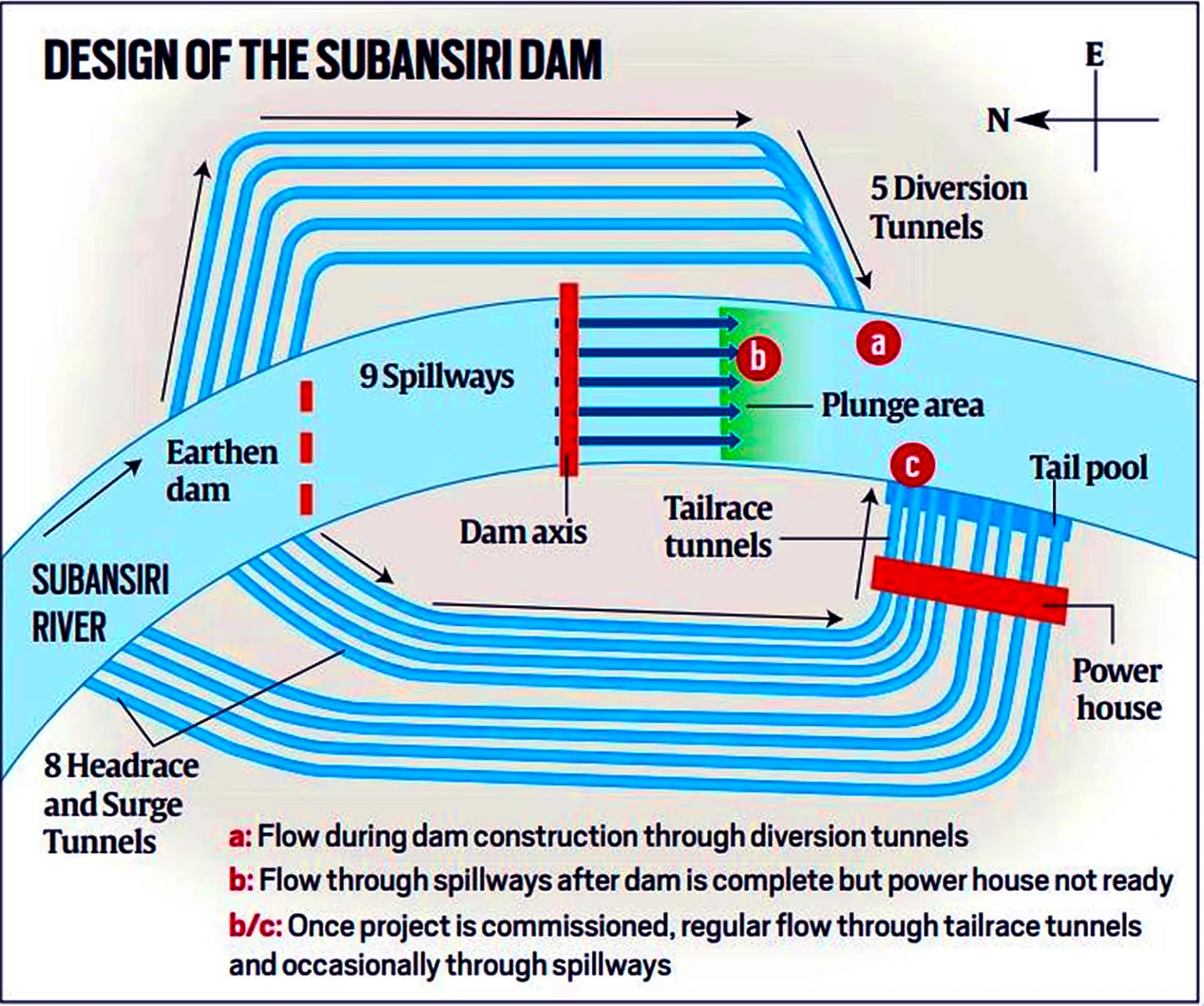
The Subansiri Lower Hydroelectric Project, located at Gerukamukh on the Assam–Arunachal Pradesh border, is India’s largest run-of-the-river hydropower project under construction. Implemented by NHPC, it will generate 2000 MW through eight units of 250 MW each.
- Unit 1 and Unit 2 have started test generation.
- Three more units are expected by December 2025.
- The full commissioning is targeted for March 2027.
Once operational, the project will supply 7.421 billion units of renewable energy per year, supporting India’s carbon-neutrality ambitions.
Understanding the Project: Key Technical Features
- Type: Run-of-the-river scheme – uses natural river flow with minimal storage.
- Developer: NHPC Ltd. (National Hydroelectric Power Corporation)
- Dam Height: 116 metres, concrete gravity dam.
- Reservoir Length: 34.5 km (storage: 1365 MCM + 442 MCM flood cushion).
- Diversion System: 5 diversion tunnels.
- Spillways: 9 spillway bays for controlled release.
- Powerhouse: Underground structure with 8 × 250 MW turbines.
These design features help balance power generation, flood moderation, and ecological flow.
About the Subansiri River
- The Subansiri River, also known as Chayul Chu in Tibet, is the largest tributary of the Brahmaputra, contributing nearly 7.92% of its total flow.
- It is a right-bank tributary of the Brahmaputra.
- It is a trans-Himalayan river flowing through Tibet (China), Arunachal Pradesh, and Assam before joining the Brahmaputra at Jamurighat in Lakhimpur district.
- Known as Gold River for its historic gold dust (Xiphoid sand).
Origin and Course
- The river originates in the mountains of Tibet, where several “Chu” streams (notably Sikung Chu) form its upper course .
- Total length: ~442 km
- ~192 km in Arunachal Pradesh
- ~190 km in Assam
- Rest in Tibet
- It enters India near Taksing at Upper Subansiri district of Arunachal Pradesh.
- It then flows along the Miri Hills, and descends into the Assam plains at Dulangmukh.
Geographical Features
- Drainage basin: ~32,640 sq km
- Known for its steep gradients, rapid flows, and braided channels in the plains.
- Important tributaries include Rangandi, Dikrong, and Kamala.

Project’s Long Journey: 20 Years of Challenges & Resilience
1. Halt in Construction (2011–2019)
Assam witnessed massive protests led by civil groups, environmentalists, and experts citing:
- Dam safety concerns,
- Seismic vulnerability,
- Downstream ecological impact,
- Risk of sudden floods.
All work stopped for eight years, leading to cost escalation from ₹6,285 crore (2002) to nearly ₹26,000 crore.
Safety Reforms and Expert Panels: How the Project Was Strengthened
To address public concerns, the Union Government constituted multiple high-level committees:
1. Technical Expert Committee (TEC), 2012
- Rejected fears of “dangerous hydrological design”.
- Recommended increased safety margins.
2. Dam Design Review Panel (DDRP), 2013
Suggested major upgrades:
- Widening dam base from 171m → 271m
- Additional cut-off walls
- Strengthened grouting and anchoring
- Enhanced seepage protection
3. National Committee for Seismic Design Parameters (NCSDP)
- Approved upgraded seismic safeguards.
4. Cumulative Impact and Carrying-Capacity Study (CWC, 2014)
Mandated:
- Minimum environmental flow of 240 cubic metres/second
- Long-term river health monitoring
- Downstream ecological protections
Ecological & Safety Measures for Downstream Assam
Key Protection Measures
- A 15-meter flood cushion to absorb sudden inflows.
- 442 MCM buffer capacity for flood moderation.
- 60 km of riverbank protection downstream.
- Raised carrying capacity (15–20%) of the Subansiri channel.
- ₹470 crore community welfare and infrastructure package for affected villages.
These steps aim to reduce flood anxiety among downstream communities.
Power Allocation: Who Gets What?
- Assam:
- Standard allocation: 208 MW
- Additional preferential: 300 MW
- 25 MW free electricity
- Arunachal Pradesh:
- 12% free power as the “host state”
Remaining power is allocated to other states, including those in the Northeast.
Importance for India’s Energy Transition
The project contributes directly to:
- India’s National Hydropower Policy goals
- Paris Agreement commitments
- 2030 renewable energy targets
- Stabilising the Northeast’s grid
- Reducing coal dependence
Exam Hook: Key Takeaways
- India’s largest run-of-river hydropower project under construction.
- 2000 MW capacity; 8×250 MW units.
- Crucial safety redesign after public protests.
- Subansiri: Trans-Himalayan river, meets Brahmaputra near Majuli.
- Reservoir: 34.5 km; dam: 116 m high.
- Environmental flow mandated: 240 cumecs.
Mains Question
“The Subansiri Lower Hydroelectric Project illustrates the complex balance between development, ecology, and public consent in the Northeast. Discuss.”
Share This Story, Choose Your Platform!
Start Yours at Ajmal IAS – with Mentorship StrategyDisciplineClarityResults that Drives Success
Your dream deserves this moment — begin it here.