

Syllabus: GS-III: Infrastructure
Why in the News?
The Union Minister of State for Road Transport and Highways announced that a 658-kilometre Indo–Myanmar border road is under feasibility study and is likely to be declared a new National Highway, marking a major step in strengthening connectivity, security and trade in Manipur and the wider Northeast.
What Is the Indo–Myanmar Border Road Project?
The project proposes the construction of a 658-kilometre long National Highway running parallel to the India–Myanmar border. It aims to:
- Strengthen border infrastructure
- Improve strategic mobility for armed forces
- Enhance regional connectivity
- Support Act East Policy and trade links with Southeast Asia
Once approved, it will become one of India’s longest border highways.
Present Status of Road Development in Manipur
According to the minister, the Ministry of Road Transport and Highways is currently developing 11 National Highways in Manipur, covering 1,774 kilometres.
Key progress milestones include:
- 747 km already black-topped and upgraded from one-lane to two-lane highways
- Remaining 332 km to be completed by 2026–27
- 51 highway project packages underway with an expenditure of Rs 12,000 crore over the past five years
These projects are being executed mainly through:
- National Highway and Infrastructure Development Corporation Limited
- Manipur Public Works Department
Key Corridors Targeted for Completion (By 2025–26)
The government aims to complete important corridors crucial for connectivity and security:
- Imphal – Jiribam (National Highway-37)
- Yaingangpokpi – Finch Corner (National Highway-202)
- Tamenglong – Mahur (National Highway-137)
- Churachandpur – Tuivai (National Highway-102B)
- Maram – Peren (National Highway-129A)
These highways connect Manipur to Assam, Nagaland and Mizoram, strengthening interstate linkages and cross-border access.
New Projects Under Preparation
Detailed project reports are being prepared for:
- 262-kilometre Churachandpur – Tipaimukh (National Highway-02)
- 57.91-kilometre Mao – Senapati Greenfield alignment (National Highway-02)
These routes enhance access to interior districts and remote border villages.
Challenges in Implementation
The minister highlighted key bottlenecks:
- Land acquisition delays
- Forest clearance issues (especially in ecologically fragile zones)
- Difficult mountainous terrain
- Law and order concerns in certain border areas
These challenges delayed around 35 project packages, though renewed efforts are underway for timely completion.
Broader Significance of the Indo–Myanmar Border Road
A. Strategic Importance
- Enhances border management along the sensitive India–Myanmar boundary.
- Improves armed forces mobility in remote regions.
- Supports counter-insurgency and logistics operations.
B. Economic Potential
- Boosts border trade under the Act East Policy.
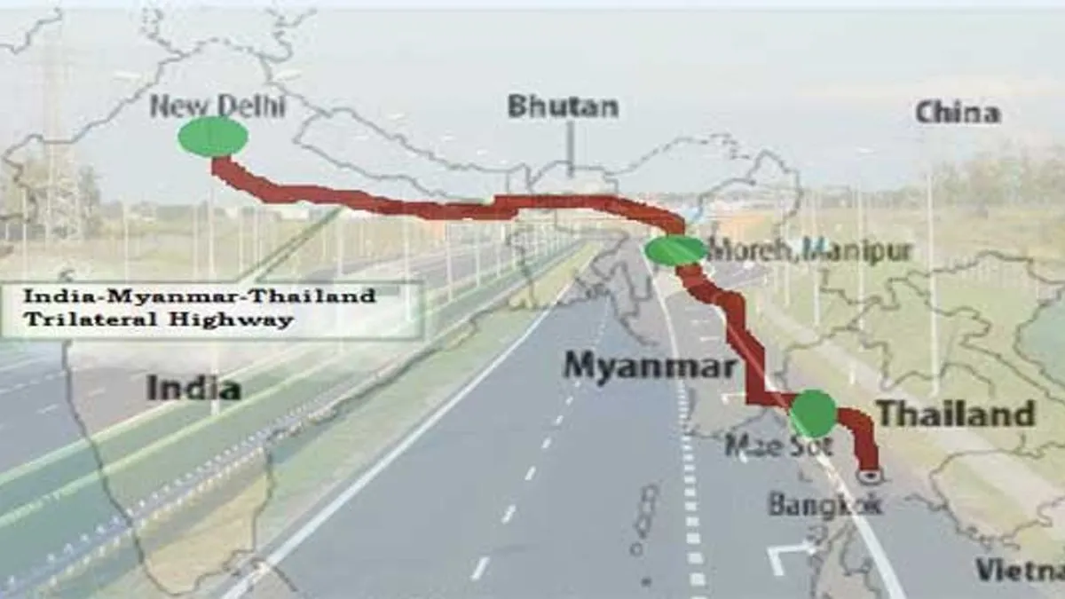
- It connects Manipur to Moreh, India’s gateway to Myanmar and Southeast Asia.
- Facilitates integration into the Trilateral Highway (India–Myanmar–Thailand) network.
C. Social Development Benefits
- Improves connectivity for tribal villages in Churachandpur, Tamenglong, Ukhrul and Senapati.
- Enhances access to health, education, markets and emergency services.
D. Governance and Environmental Perspective
- Road construction in forested regions requires safeguards under the Forest Conservation Act, 1980.
- Strengthens administrative presence in remote border areas.
- Helps curb informal crossings and smuggling by creating regulated road networks.
India–Myanmar–Thailand (IMT) Trilateral Highway
Key Points:
|
 Important Terms Explained
- National Highway: A road built and maintained by the central government for nationwide connectivity.
- Feasibility Study: A detailed assessment to check if the project is technically, economically and environmentally viable.
- Black-topping: Laying a smooth bitumen layer on the road to improve durability and driving quality.
- Greenfield Alignment: A completely new road built on a fresh land corridor, not upgrading an old road.
- Act East Policy: India’s policy to deepen trade, cultural and security ties with Southeast Asian countries.
- Border Infrastructure: Roads and facilities built along international borders for connectivity, security and trade.
Exam Hook: Key Takeaways
- Indo–Myanmar road: 658-km, under feasibility study, likely to become a new National Highway
- Part of India’s Act East Policy and strategic border development
- Major ongoing works: 1,774 km, Rs 12,000 crore, 51 packages
- Agencies involved: NHIDCL and Manipur Public Works Department
Mains Question
“Discuss the strategic and developmental significance of the Indo–Myanmar border road project in strengthening India’s Act East Policy and regional security.”
Share This Story, Choose Your Platform!
Start Yours at Ajmal IAS – with Mentorship StrategyDisciplineClarityResults that Drives Success
Your dream deserves this moment — begin it here.